Showing posts with label tropical storm ida photos. Show all posts

Monday, November 16, 2009

Underwater World: The Wrack of Ida on the Carolina Coast

This past weekend I headed to the coast to assist the UNC Chapel Hill Vert. Zoology class on a birding field trip. Fortunately, the timing was perfect. The trip would coincide with the tail-end of the Nor'Easter passing by... giving me the rare opportunity of being able to witness, first hand, the damage brought to our coastline.

Locals said that this was the biggest storm since Isabel in 2003, and the evidence supports it. In Nags Head, dunes disappeared and beachside boardwalks were buried in a foot of sand, while the surf was littered with the shards of docks. Driving throughout the Pamlico Peninsula, settlement after settlement had sections underwater, and most fields had become temporary ponds.

Not something you see everyday. Thankfully for you, I have a few photos to give you some idea. Strap on your belts and take a ride!


We were stationed on the Outer Banks in Nags Head at the Sea Foam Motel, a weathered, somewhat charming establishment. Above is the view at dawn on Saturday, November 14th. Still a 20-30 mph NW wind, large swells.


Here is a view looking North along the beach, where you can see the sand bag wall. The goal of these sand bags is to prevent the onslaught of the ocean as the Outer Banks erode inland, slowly but surely.


Above is the shower head behind the motel. It may be hard to tell in this photo, but it's under 1.5 feet of sand... only a hobbit could bathe under this.


Continued signs of the sand deposition... here is the staircase leading to the oceanfront gazebo. As you can see, the steps are under sand and the hand-rail is more like an ankle-rail.


"Walk down the steps and enter the ocean," the sign should read. All morning, waves broke onto the gazebo.


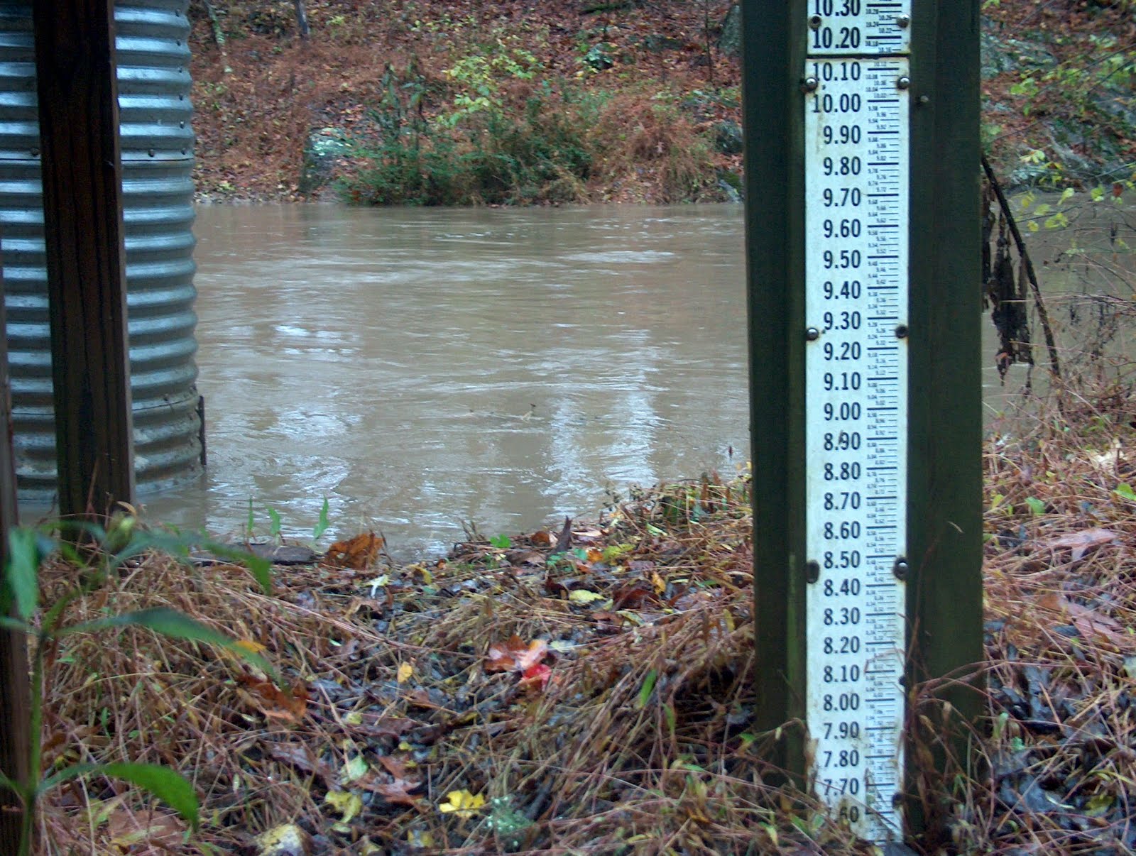
Leaving the Outer Banks and back on the mainland now, here are some photos of the town of Engelhard on the Pamlico Peninsula. A small town, a water world. There's not a whole lot you can do to combat it, other than to move your car to high ground and wait for the water to recede. Many areas totaled over a foot of rain the past week, too much for the earth to soak up.


But, even in dire times, someone benefits. Riiight? Some thrive in such conditions. Like beavers. Too bad this 50 pounder decided to cross the road. His life may be forfeit, but he would be happy to know how much we loved prodding him. He was very fresh.


Whether it be in New Orleans, Bangladesh, or North Carolina... some places are, by definition, disaster zones in waiting. The unique ecosystems of these areas have been created by, and depend on, storms like these. It is a fact that the barrier islands along the Carolina coast are geologically unstable, shifting sands that are incompatible with permanent structures and associated human habitation.

It just so happens that humans feel the benefits outweigh the negatives in living here. What is it that binds them to these risky places? Is it family tradition? The ocean front? The natural resources?

Most certainly it is all of the above... but let it be known...

Storms will persist, separate from man's desire.

Ida: All That Rain Last Week

In September of 1989 Hurricane Hugo blew through Charlotte NC, leveling trees, cutting power, and to young me, creating the greatest jungle gym he would ever see.

Flipping through the T.V. channels as a growing boy, the channels I flipped through included TNT for Scooby Doo, PBS for Wishbone, ESPN for sports, and Cable Channel 41, the Weather Channel. During late summer and fall, my days revolved around the Tropical Update at the :50 of every hour. I envied the cue-ball head of Jim Cantore as he stood in the midst of 120 mph winds, lusted after the opportunity to stand a foot deep in a horizontal, driving snow.

So, when I became aware of Tropical Storm Ida churning in the Gulf of Mexico last week, I kept a casual eye on the reports. I read that, once making landfall, the winds would bring it towards the Carolinas. I also read that as it did so, it would team up with a low pressure system off of the southeastern coast, creating a two-fold storm, the swirling comma of a Nor'Easter.

Yay.

As everyone with a pulse now knows, it wound up raining a ton last week, whether you were in the Appalachians, piedmont or coastal plain. Instinct told you stay cooped up during all that rain. To stay sheltered, warm, lazy, fat. A mini-hibernation. On the other hand, for me, cursed by the Hugo Effect, my urges lay elsewhere. Outside.

As the Flood Warnings were posted, the Wind Advisories issued, I thought of Morgan and Bolin Creek. How fat would they get?

So, what else to do but go find out? The afternoon of November 11th I went out to survey the situation. Here are the photos.


Running southeast out of town, Morgan Creek drains a great deal of the town's runoff. I went to check on it behind Finley Golf Course, along the entrance road to Mason Farm Biological Reserve. Above is the water level, below, a pan of the swollen channel.


As I continued down the road, my trip came to an abrupt halt. The road had become a torrent, as the adjacent beaver pond had jumped its banks, connecting the two bodies of water. Below, a great blue heron spends its time fishing in the road. Its not a road to him! Just more water.


I continued on foot, where I discovered the weir to be way underwater!!!


Looking up from the middle of the road. Below, looking down.


And of course, the casualties. The taming of the shrew.


Why do this? I don't know, and back then I didn't even need to know. But as I ponder it now, I believe part of it is this: There is no greater force, no more dominant power, than what our planet churns.

So what greater thrill can there be, other than to subject yourself, in complete submission, to this power? To immerse yourself in the driving force. How unnecessary thoughts seem when our senses are firing so intensely.